SMELLED IT…

CHILEAN QUAKE CAUSED ICEQUAKES IN ANTARCTICA

The ice sheets in Antarctica vibrated a bit more than usual because of something more than 3,000 miles away : 8.8 magnitude Chilean earthquake . A study has found that Antarctica’s  frozen ground is sensitive to seismic waves from distant earthquakes .

Some of the ice quakes were quick bursts and over less than one second .Others were long duration,tremor signals up to 10 seconds. 

                                               MASSIVE CHILEAN EARTHQUAKE

chile-quake

DIGGING OUR OWN GRAVE…

WELL THIS REMINDS ME OF THE QUOTATION THAT “NOTHING IS BEYOND MAN’S REACH”

NOT A JOKE BUT YES IT IS POSSIBLE TO CREATE YOUR OWN EARTHQUAKE ……BUT UNFORTUNATELY THIS IS NOT A MATTER OF BEING PROUD OF THE “TECHNICAL ACHIEVEMENT” BUT A MATTER OF IMMENSE “SHAME” FOR THE ENTIRE HUMANITY… 

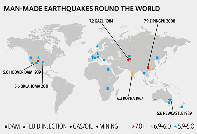
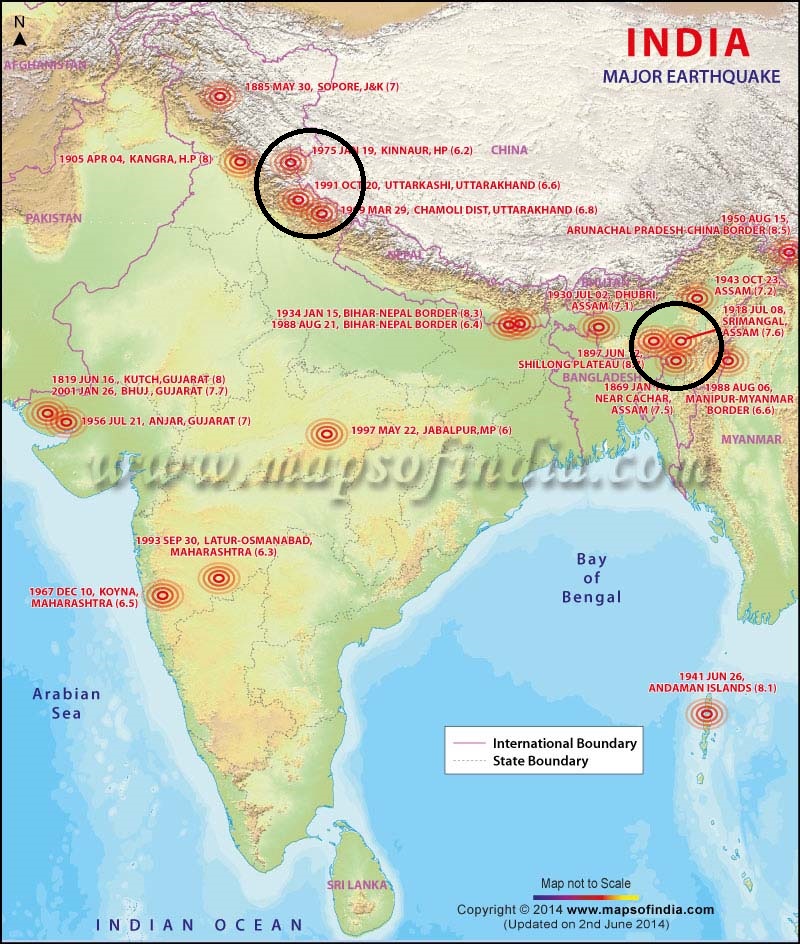
Here is a list of “human efforts” to call the “death”

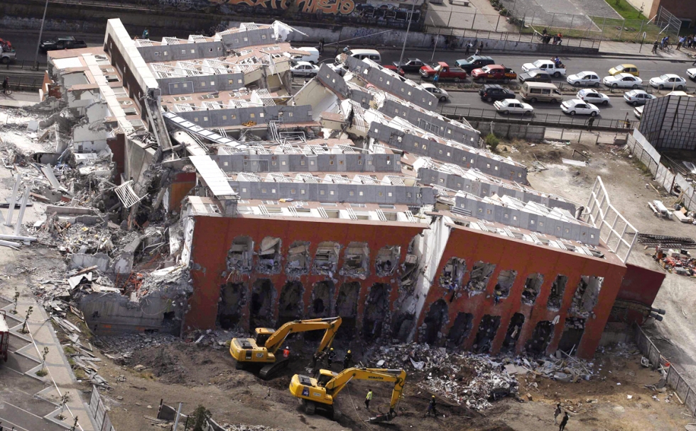
2008 Sichuan, China earthquake

It’s just water, but, man, water is heavy. Large reservoirs of water created by dams have a long history of inducing earthquakes, from Zambia to Greece to India. The 2008 earthquake in Sichuan, China, that killed nearly 70,000 people was one of the most devastating in recent memory, and some scientists think it was triggered by the construction of the Zipingpu Dam nearby.

The Zipingpu Dam sits just a third of a mile away from the fault, and the added weight of millions of tons of water could have hastened the fault’s rupture. “No geological process can come up with such a concentration of mass in such as small area other than a volcano,” said geologist Christian Klose about the buildup of water.

Groundwater extraction — 2011 Lorca earthquake

Taking water out of ground, which causes the water table to drop, can also destabilize an existing fault.

A 2011 earthquake in Lorca, Spain caused a great amount of destruction for its 5.1 magnitude because its epicenter was located so close to the surface. Its shallow epicenter may be related to groundwater extraction near Lorca, according to research published in Nature Geoscience. Since 1960, water extraction has caused the region’s water table to drop by an incredible 250 meters.

Geothermal power plants — Salton Sea Geothermal Field and The Geyers Geothermal Field

snapshot_03_slide_03_1_schem_landschaft_fin_EN

At the end of the infamous San Andreas Fault in California lies the Salton Sea—and, along its southern shore, is the Salton Sea Geothermal Field. The power plant extracts hot, high-pressured water out of the ground and turns it into steam to run turbines generating power. If it seems like a bad idea to be extracting water so close to the San Andreas Fault, well, you’d be right.

In a 2011 study published in Science, researchers at the University of California, Santa Cruz, found that seismic activity has increased around the Salton Sea as geothermal field operations have ramped up. Earthquake swarms—bursts of dozens of small quakes below magnitude 6 or so—happen regularly along the Salton Sea. While these earthquake swarms by themselves may not cause much damage, they could interact with other bigger faults, like the San Andreas located so conveniently nearby, to induce far more damaging quakes.

Several hundred miles north in California is also the Geysers Geothermal Field, the largest geothermal field in the world. Because the Geysers don’t sit near a large fault, induced seismicity there is less likely to be majorly destructive. However, researchers have found that seismicity in the region has increased from basically zero in the 1960s to 20 or 30 small seismic events per year.

Fracking and injection wells — 2011 Oklahoma earthquake

When it comes to hydraulic fracturing, or fracking, it’s actually not the extraction of oil or gas that’s the problem. . It’s what happens to those afterward, when waste fracking fluid is injected back underground into deep wells. The fluid can seep out and lubricate faults, causing them to slip more easily. A study in Geology links a 2011 Oklahoma earthquake to wastewaterinjection wells.

Seismic activity in Oklahoma has shot up along with the rise of fracking: The number of earthquakes went from about a dozen in 2008 to over 1,000 in 2010. Earthquake swarms are now regular occurrences in the region. With fracking in the United States steadily increasing, the dangers of wastewater injection wells become more imminent.

Skyscrapers — Taipei 101

terremotos-como-medir-sua-intensidade-14

The tallest building in the world when it was built, the Taipei 101 tower in Taiwan was supposed to be the city’s crown jewel, capable of withstanding typhoon winds and earthquakes. Ironically, the very things supposed to make it earthquake-resilient may be… causing earthquakes.

According to a Taiwanese geologist Cheng-Horn Lin, Taipei 101’s especially huge mass of 770,000 tons is putting too much pressure on the soft sedimentary rock below. This stress is due to all the extra steel and concrete used to make the skyscraper solid enough to withstand earthquakes. Since construction began on Taipei 101, according to Lin, the region has seen several micro-earthquakes and two larger earthquakes directly underneath the building.

During its construction in March 2002, a 6.8 earthquake did knock two cranes to the ground. Taipei 101 itself, though, was undamaged. So, if the skyscraper does cause earthquakes in the future, at least you know where to go?

Overenthusiastic Sports Fans — Seahawks Game, Seattle

When the Seattle Seahawks scored a touchdown on a fumble return last week, the seismometer down the block was keeping score. The University of Washington’s seismometer just one block south of CenturyLink Field registered a magnitude 1 or 2 earthquake from the rumbling of Seahawks fans. When your seismometer is so close, though, does it even really count? Well, here’s an empowering message: Stand close enough to a seismometer and you, too, can cause your very own earthquake.

NATURALITY LOST …

MAN MADE EARTHQUAKES

In the first Superman movie, supervillain Lex Luthor plans to trigger a massive, California-detaching earthquake by detonating a couple of nuclear weapons in the San Andreas Fault.

Crazy Lex! That scheme never would have worked, geologists will tell you. But, if he’d been serious about creating an earthquake, there are ways he could have actually done it. He would just have to inject some liquid (as some carbon-sequestration schemes propose) deep into the Earth’s crust, or bore a few hundred thousand tons of coal out of a mountain.

It turns out, actually, that the human production of earthquakes is hardly supervillain-worthy. It’s downright commonplace: Klose estimates that 25 percent of Britain’s recorded seismic events were caused by people.

Most of these human-caused quakes are tiny, registering less than four on geologist’s seismic scales. These window-rattlers don’t occur along natural faults, and wouldn’t have happened without human activity — like mining tons of coal or potash. They occur when a mine’s roof collapses, for example, as in the Crandall Canyon collapse in Utah that killed a half-dozen miners last year.

240314_earthquake_5_650

But some human actions can trigger much larger quakes along natural fault lines. That’s because humans, with the aid of our massive machines, can sling enough mass around to shift the pattern of stresses in the
Earth’s crust. Faults that might not have caused an earthquake for a million years can suddenly be pushed to failure, as Klose argues occurred during Australia’s only fatal earthquake in 1989.

NEXT POST ON …….WAYS TO CREATE EARTHQUAKES

METEOR SHOWER…

The 2014 Perseid meteor shower will peak between August 10 and August 13. A waning Gibbous Moon (the Moon’s phase after a full moon) may make it harder for observers to see the shower. Despite this, astronomers suggest that observers try their luck to catch some Perseids before dawn on August 11, 12 and 13.

The Perseid meteor shower, one of the brighter meteor showers of the year, occur every August, peaking around August 9-13. Consisting of tiny space debris from the comet Swift-Tuttle, the Perseids are named after the constellation, Perseus. This is because, their radiant or the direction of which the shower seems to come from lies in the same direction as Perseus. The constellation lies in the north-eastern part of the sky.

While the skies light up several time a year by other meteor showers , the Perseids are widely sought after by astronomers and stargazers alike. This is because at its peak, one can view 60 to a 100 meteors in an hour from a dark place.

perseid-map


Where to view

The Perseids can be viewed by observers in the Northern Hemisphere. If you are planning to view the shower, look between the radiant, which will be in the north-east part of the sky and the zenith (the point in sky directly above you). But don’t worry, you do not have to make any major astronomical calculations. Just lay a blanket on the ground, lie down and let your eyes wander around the sky – you will be bound to spot the shower sooner or later.

When to view

The best time to view the Perseids, or most other meteor showers is when the sky is the darkest. Most astronomers suggest that depending on the Moon’s phase, the best time to view meteor showers is right before dawn.

How to view

There isn’t a lot of skill involved in watching a meteor shower. Here are some tips on how to maximize your time looking for the Perseids:

  • Get out of the city to a place where city and artificial lights do not impede your viewing
  • If you are out viewing the shower during its peak, you will not need any special equipment. You should be able to see the shower with your naked eyes.
  • Carry a blanket or a comfortable chair with you – viewing meteors, just like any other kind of star gazing is a waiting game, and you need to be comfortable. Plus, you may not want to leave until you can’t see the majestic celestial fireworks anymore.
  • Check the weather and moonrise and moonset timings for your location before you leave, and plan your viewing around it.

EARTHQUAKES EXPLAINED…

How Do Earthquakes Occur?

Earthquakes are usually caused when rock underground suddenly breaks along a fault. This sudden release of energy causes the seismic waves that make the ground shake. When two blocks of rock or two plates are rubbing against each other, they stick a little. They don’t just slide smoothly; the rocks catch on each other. The rocks are still pushing against each other, but not moving. After a while, the rocks break because of all the pressure that’s built up. When the rocks break, the earthquake occurs.

earthquake_guide466

During the earthquake and afterward, the plates or blocks of rock start moving, and they continue to move until they get stuck again. The spot underground where the rock breaks is called the focus of the earthquake. The place right above the focus (on top of the ground) is called the epicenter of the earthquake.

Earthquake-like seismic waves can also be caused by explosions underground. These explosions may be set off to break rock while making tunnels for roads, railroads, subways, or mines. These explosions, however, don’t cause very strong seismic waves. You may not even feel them. Sometimes seismic waves occur when the roof or walls of a mine collapse. These can sometimes be felt by people near the mine.

earthquake

NEXT POST ON       MAN MADE EARTHQUAKES

 ……KEEP VISITING !!!!

THE RAREST OF THE RARE…

The Assam earthquake of 1897 occurred on June 12 in Assam, British Raj, and had an estimated moment magnitude of 8.1.Considering the size of the earthquake, the mortality rate was not that high, with about 1,500 casualties, but property damage was very heavy.

Thought to have happened 20 miles (32 km) underground, it left 150,000 square miles (390,000 km2) of masonry buildings in ruins and was felt over 250,000 square miles (650,000 km2) from Burma to New Delhi. Numerous buildings in the neighboring country of Bhutan were heavily damaged. There were very many aftershocks.

410806aa.2

CAUSE?

University of Colorado at Boulder Professor Roger Bilham and OXFORD UNIVERSITY Professor Philip England believe the Assam earthquake most likely was caused by two adjacent faults rupturing beneath the Earth’s surface in India near Bangladesh. Estimated to be an 8.1 magnitude quake, the extremely violent event caused part of the overlying Shillong Plateau to shoot up nearly 50 feet in just three seconds.

The new analysis indicates “the acceleration from the epicenter of the earthquake some 10 miles deep exceeded that of gravity, causing boulders, tombstones and even people to be tossed into the air,” .

F2.large

This represents the first quantitative observation of active deformation of a ‘pop-up’ structure, and confirms that faults bounding such structures can penetrate the whole crust,

The models also show the primary fault, dubbed the Oldham fault, is about 78 miles long, dips away from the Himalayas and lies between five to 20 miles underground. Bilham and England also inferred there must be a second fault on the south edge of the plateau that acts in concert with the Oldham fault to wedge the Shillong Plateau uniformly upward without TILTING it.

The Indian plate was being pushed up against the Himalayas, causing a portion of the land surface on the Shillong Plateau to pop up like a segment of a peeled orange would pop up under pressure,”. ” the slip of the fault to be about 15 meters, one of the largest slips ever calculated for any earthquake.”

“Fortunately, an earthquake as powerful as the Assam event only occurs about once every 3,000 years on the Oldham fault,” said Bilham. “They are very rare, but could be extremely devastating in this region given the huge population of people now living in Bangladesh and the POOR construction practices there.”

410806ac.2

THE RING OF FIRE …

WHAT IS IT ?

The Ring of Fire is a string of volcanoes and sites of seismic activity, or earthquakes, around the edges of the Pacific Ocean.

The Ring of Fire isn’t quite a circular ring. Its shaped more like a 40,000-kilometer (25,000-mile) horseshoe. A string of 452 volcanoes stretches from the southern tip of South America, up along the coast of North America, across the Bering Strait, down through Japan, and into New Zealand.

28481

HOW FORMED ?

The Ring of Fire is the result of plate tectonics. The edges of several tectonic plates meet along the Ring of Fire, resulting in a convergent boundary, a divergent boundary, or a transform boundary.

1) A convergent plate boundary is formed by tectonic plates crashing into each other. Convergent boundaries are oftensubduction zones, where the heavier plate slips under the lighter plate. Subduction zones are frequently sites of volcanoes, as the heavier plate melts back into the Earthsmantle.

                                                                 A CONVERGENT BOUNDARY

3051893_orig

2) A divergent boundary is formed by tectonic plates pulling apart from each other. Divergent boundaries are the site ofseafloor spreading. Seafloor spreading is the process ofmagma welling up in the rift as the old crust pulls itself in opposite directions. Cold seawater cools the magma, creating new crust.

                                                                       A DIVERGENT BOUNDARY

14djgjgfk

3) A transform boundary is formed by two tectonic plates sliding next to each other. Transform boundaries are often the site of earthquakes in the Ring of Fire.

                                                                         A TRANSFORM BOUNDARY

transform

ALL THE THREE PROCESSES OCCURRING SIMULTANEOUSLY

7802165

Active Volcanoes

The Ring of Fire is the home of most of the active volcanoes on Earth, most of them located on the rings eastern edge.Mount Ruapehu in New Zealand is one of the more active volcanoes in the Ring of Fire, with yearly minor eruptions and major eruptions occurring about every 50 years. It stands 2,797 meters (9,177 feet) high.

Krakatoa, an island in Indonesia, erupts less often than Mount Ruapehu, but much more spectacularly. Beneath Krakatoa, the Australian Plate is being subducted beneath the Eurasian Plate. An eruption in 1883 destroyed the entire island, sending volcanic gas, ash, and rocks as high as 80 kilometers (50 miles) in the air. A new island volcano, Anak Krakatau, has been forming with minor eruptions ever since.

                                                          MOUNT RUAPEHU – AN ACTIVE VOLCANO

Turoa-Overview-02

“LINK NOT FOUND”…

THE BIGGEST MYSTERY ….CAN ANIMALS PREDICT THE UNPREDICTABLE ??? 

Earthquakes are a sudden phenomenon. Seismologists have no way of knowing exactly when or where the next one will hit.

We can’t tell when an earthquake is about to strike, but some people believe other animals can. Most scientists say no, but a few aren’t so sure. There have been hundreds of reports of cats, dogs, cockroaches, and rats becoming disoriented and disturbed prior to earthquakes.

FEW REPORTED INCIDENT…

1) In 1975, people reported in northeastern China mice and rabbits leaving their burrows and    snakes coming out of hibernation in the middle of the winter before a huge earthquake occurred.

2) The night before the big 1906 earthquake, horses in San Francisco grew panicky.

3) Other signs from animals that an earthquake is coming includes birds flying in circles, dogs barking for hours and elephants starting to run.

4) The day before the 1964 Good Friday Earthquake, Alaska’s Kodiak bears came out of hibernation weeks before schedule.

131212142215-large image

Consistent and reliable behavior prior to seismic events, and a mechanism explaining how it could work, still eludes us.  Most, but not all, scientists pursuing this mystery are in China or Japan.

We can easily explain the cause of unusual animal behavior seconds before humans feel an earthquake.  Very few humans notice the smaller P wave that travels the fastest from the earthquake source and arrives before the larger S wave. But many animals with more keen senses are able to feel the P wave seconds before the S wave arrives.  

However, much research still needs to be done on this subject. 

EARTH’S COUSIN…

Untitled1

A new earth Kepler-186f is an exoplanet orbiting the red dwarf Kepler-186 about 500 light-years from the Earth.It is the first planet with a radius similar to Earth’s to be discovered in the habitable zone of another star. NASA‘s Kepler spacecraft detected it using the transit method, along with four additional planets orbiting much closer to the star (all modestly larger than Earth).Analysis of three years of data was required to find its signal.The results were presented initially at a conference on 19 March 2014 and some details were reported in the media at the time. The full public announcement was on 17 April 2014, followed by publication in Science.

Untitled2