WHAT IS IT ?
The Ring of Fire is a string of volcanoes and sites of seismic activity, or earthquakes, around the edges of the Pacific Ocean.
The Ring of Fire isn’t quite a circular ring. Its shaped more like a 40,000-kilometer (25,000-mile) horseshoe. A string of 452 volcanoes stretches from the southern tip of South America, up along the coast of North America, across the Bering Strait, down through Japan, and into New Zealand.

HOW FORMED ?
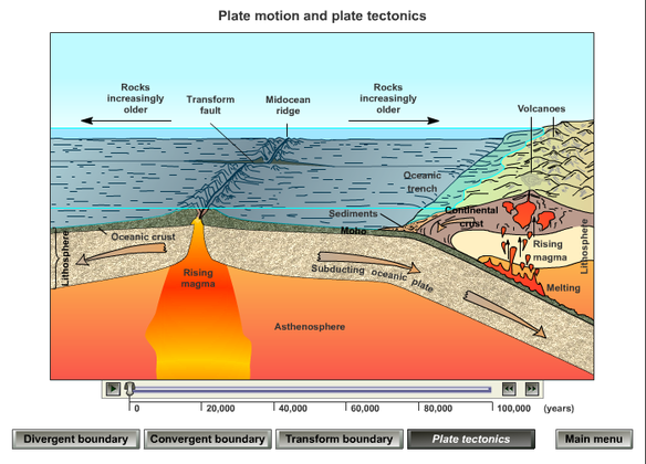
The Ring of Fire is the result of plate tectonics. The edges of several tectonic plates meet along the Ring of Fire, resulting in a convergent boundary, a divergent boundary, or a transform boundary.
1) A convergent plate boundary is formed by tectonic plates crashing into each other. Convergent boundaries are oftensubduction zones, where the heavier plate slips under the lighter plate. Subduction zones are frequently sites of volcanoes, as the heavier plate melts back into the Earthsmantle.
A CONVERGENT BOUNDARY

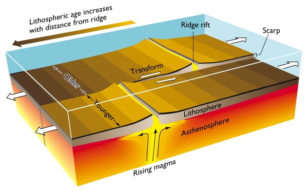
2) A divergent boundary is formed by tectonic plates pulling apart from each other. Divergent boundaries are the site ofseafloor spreading. Seafloor spreading is the process ofmagma welling up in the rift as the old crust pulls itself in opposite directions. Cold seawater cools the magma, creating new crust.
A DIVERGENT BOUNDARY

3) A transform boundary is formed by two tectonic plates sliding next to each other. Transform boundaries are often the site of earthquakes in the Ring of Fire.
A TRANSFORM BOUNDARY
ALL THE THREE PROCESSES OCCURRING SIMULTANEOUSLY
Active Volcanoes
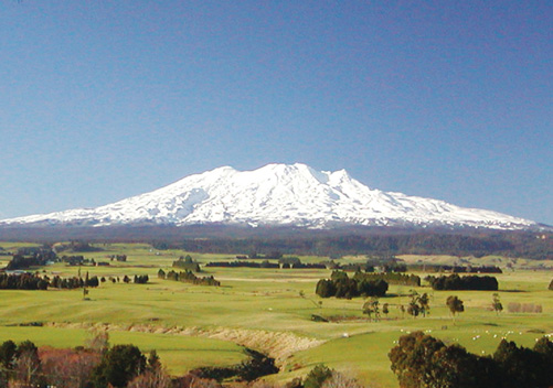
The Ring of Fire is the home of most of the active volcanoes on Earth, most of them located on the rings eastern edge.Mount Ruapehu in New Zealand is one of the more active volcanoes in the Ring of Fire, with yearly minor eruptions and major eruptions occurring about every 50 years. It stands 2,797 meters (9,177 feet) high.
Krakatoa, an island in Indonesia, erupts less often than Mount Ruapehu, but much more spectacularly. Beneath Krakatoa, the Australian Plate is being subducted beneath the Eurasian Plate. An eruption in 1883 destroyed the entire island, sending volcanic gas, ash, and rocks as high as 80 kilometers (50 miles) in the air. A new island volcano, Anak Krakatau, has been forming with minor eruptions ever since.
MOUNT RUAPEHU – AN ACTIVE VOLCANO